Wales
Cadair Bronwen
783M
2570FT
About Cadair Bronwen
Rising as a broad, peat-clad dome in the northern Berwyns, this Hewitt offers a quieter alternative to its loftier neighbor, Cadair Berwyn. The terrain is often damp underfoot, but the expansive plateau provides a fantastic vantage point across the Upper Dee Valley toward the rugged profiles of the Arenig and Snowdonia ranges.
Key Statistics
Rank
48th Highest in Wales
Parent Range
Snowdonia
Prominence
?
73.3m
Nearest Town
Corwen
Geology
You are walking upon the Llangynog Formation. This fell is composed of mudstone, a fine-grained rock formed from layers of compressed silt.
Find It
OS Grid Reference
SJ077346
Latitude
52.9009°N
Longitude
3.3736°W
Did You Know?
- •The name translates from Welsh as 'Bronwen’s Chair'. While some link it to the heroine Branwen from the Mabinogion, 'bron' also describes a rounded hillside or 'breast', suggesting a descriptive name for the hill’s profile.
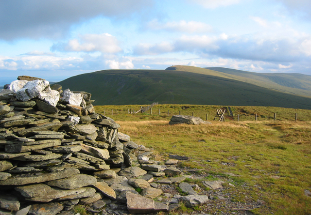
- •The summit is marked by a substantial prehistoric burial cairn known as Bwrdd Arthur (Arthur’s Table), which has been utilized by generations of walkers to create a sheltered spot on the exposed plateau.
- •A popular approach follows the 'Wayfarer’s Pass' to the south, a high track named after cycling journalist Walter Robinson, who established a tradition of leaving a logbook in a metal box for passers-by to sign.
- •From the top, there is a clear, commanding view of the massive eastern faces of the Aran mountains and the rolling green tops of the Clwydian Range to the north.
- •Despite the regal 'chair' in its name, the approach involves navigating a network of peat hags that are less of a royal seat and more of a persistent drainage challenge.