Scotland
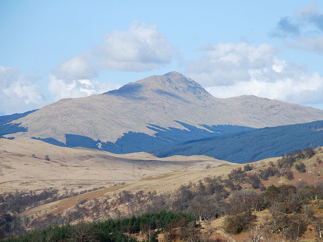
Beinn Bhuidhe
949M
3112FT
About Beinn Bhuidhe
Tucked away at the head of Glen Fyne, this solitary Munro provides a sense of isolation rarely found so close to the Central Belt. Its steep, craggy eastern face gives way to a spacious summit plateau, offering a rugged, wild character that feels distinct from the more frequented Trossachs peaks.
Key Statistics
Rank
18th Highest in Region
Parent Range
Loch Lomond and the Trossachs
Prominence
?
592m
Nearest Town
Inversnaid
Geology
You are walking on ancient layers of hardened limestone and sandstone. These are mixed with tough, heat-altered volcanic rocks and shiny, flaky stones shaped by immense pressure.
Find It
OS Grid Reference
NN203187
Latitude
56.3265°N
Longitude
4.9078°W
Did You Know?
- •The name is derived from the Scottish Gaelic 'Beinn Bhuidhe', meaning 'Yellow Hill'. This refers to the specific hue of the grasses and sedges on its slopes, which turn a distinct tawny gold during the winter months.
- •Known for one of the longest approaches of any southern Munro, most walkers face a seven-mile trek through Glen Fyne. Using a mountain bike for the flat estate track is the standard local strategy to reach the base of the climb at Inverchorachan.
- •The ascent is defined by the spectacular waterfalls of the Alt na h-Earba. The path climbs steeply alongside these cascades, which are particularly impressive after heavy rainfall, though they require careful footing on the surrounding damp rock.
- •From the summit, the view offers a unique perspective over the long sea loch of Loch Fyne. On a clear day, the jagged skyline of the Arrochar Alps is visible to the east, while the massive bulk of Ben Cruachan dominates the horizon to the northwest.
- •While most Munros are remembered for their summits, this one is often remembered for the brewery located at the start of the track—proving that a seven-mile walk out is significantly easier with the promise of a pint.